From central Nebraska east towards Iowa, the landscape gradually changes from the vast open spaces of the Great Plains to the rolling farmlands of the Midwest. We left behind the graze lands with beef cattle spotted here and there, we left behind the occasional stock yard. A big sign on the highway at the eastern boundary of Kearney County proclaimed the end of the cattle brand inspection zone, and I figured that was as good a boundary as any between cattle country, and the land of corn and soybeans.
From Ogallala to the Missouri River at the Iowa state line, the interstate highway generally follows the route of the North Platte River, and then the Platte River after the confluence with the South Platte. Here’s how Francis Parkman described his first look at the Platte River in this book The Oregon Trail:
A low undulating line of sand-hills bounded the horizon before us. That day we rode ten consecutive hours, and it was dusk before we entered the hollows and gorges of these gloomy little hills. At length we gained the summit, and the long expected valley of the Platte lay before us. We all drew rein, and, gathering in a knot on the crest of the hill, sat joyfully looking down upon the prospect. It was right welcome; strange too, and striking to the imagination, and yet it had not one picturesque or beautiful feature; nor had it any of the features of grandeur, other than its vast extent, its solitude, and its wilderness. For league after league a plain as level as a frozen lake was outspread beneath us; here and there the Platte, divided into a dozen threadlike sluices, was traversing it, and an occasional clump of wood, rising in the midst like a shadowy island, relieved the monotony of the waste….
Today, a state highway goes along the other side of the Platte from the interstate, and a main line of the Union Pacific railroad follows the same general route. All these roads pass through or by a string of cities and towns: Gothenburg, Kearney, Cozad, Lincoln. Compared to the East Coast or the West Coast, the highway corridor is lightly populated; but compared to the days when the Oregon Trail ran along the same general route, it has become a settled, civilized landscape.
We went across the Missouri into Iowa. Carol and I both noticed that the town of Avoca, Iowa, had been circled in my 2004 edition of the United States Road Atlas. But neither of us could remember why Avoca had been circled. Carol thought maybe someone we had met on our drive from California to Illinois in 2004 had suggested we visit Avoca. We took the Avoca exit, and drove a short distance to a small, friendly-looking Midwestern town. We saw nothing remarkable. I took a photograph of the grain elevator, just to show we had been there.
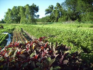
We arrived here in Ames, Iowa, at about six this evening. We’re staying at Onion Creek Farm Guest House. Joe, one of the owners, took us on a tour of the farm. He said they sell mostly to restaurants. We saw tomatoes, potatoes, squash, onions, leeks, garlic, basil, beans, kale, radishes, lettuce, carrots, amaranth, and other vegetables I can’t remember. He sold us some beans and eggs from their chickens, which we ate for supper.
One of the fields at Onion Creek Farm

